Digitization and Systematization of Historical Soil Information for the Lower Río Negro Valley
DOI:
https://doi.org/10.19137/semiarida.2026(1).61-69Keywords:
GIS, geographic information systems, soil zoning, georeferencing, QGISAbstract
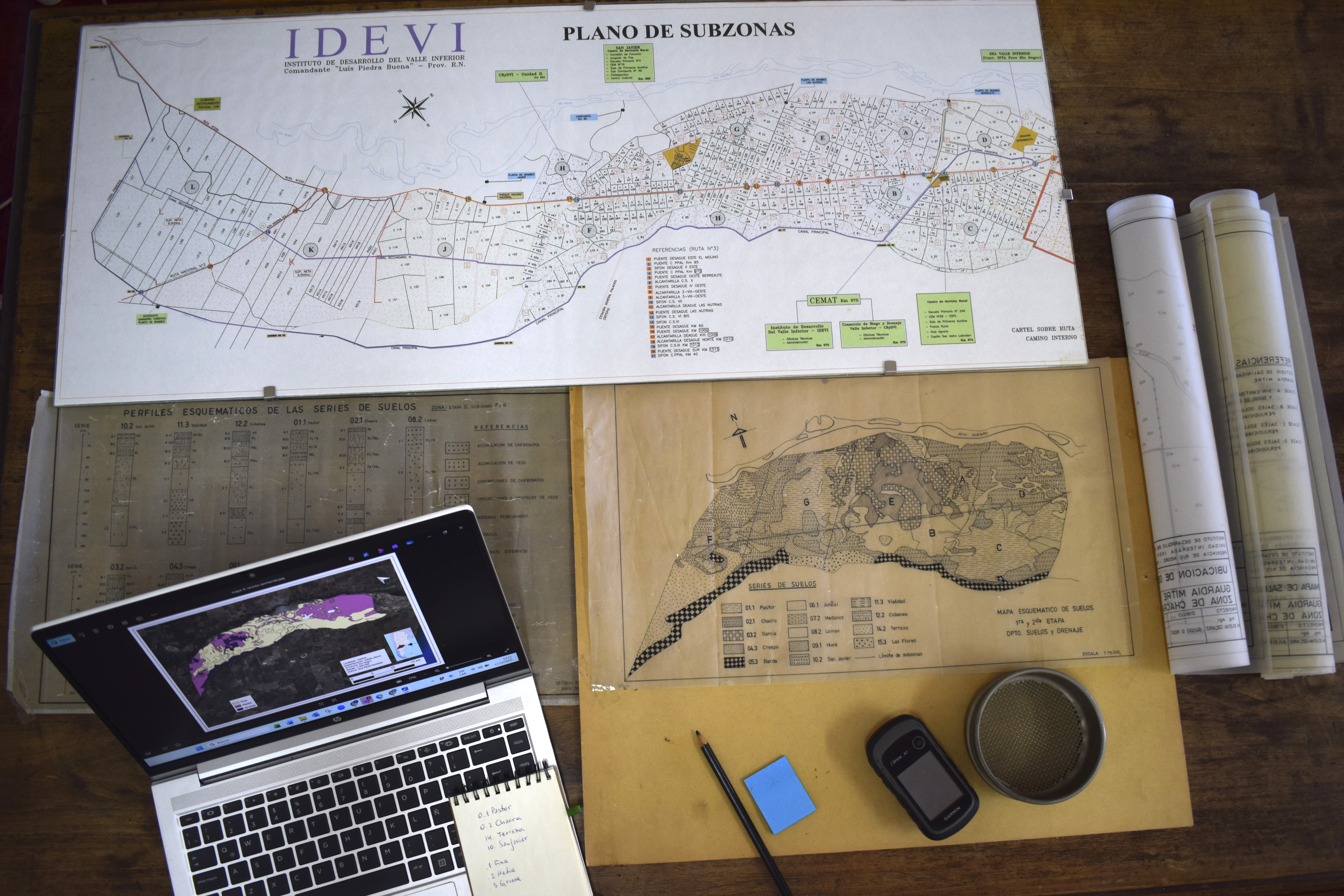
In the Lower Río Negro Valley (VIRN), during the 1960s, soil surveys were carried out that made it possible to characterize and group soils according to similarities in their components (texture, drainage, parent material, geomorphology, among others), taking into account the different profile horizons. These surveys resulted in the delineation of 15 soil mapping units of the soil-association type, represented in printed maps at a scale of 1:75,000, which are locally referred to as “soil series”. This information provided the technical basis for irrigation planning by the Lower Valley Development Institute (IDEVI). However, current access to these materials is limited due to their physical format and the partial loss of some original documents. In this context, the aim of this work was to digitize, georeference, and integrate the historical soil maps from IDEVI and their extension towards the coastal area into a unified Geographic Information System (GIS), covering a total area of 42,071 ha, using the open-source software QGIS. The main outputs include raster and vector products; unified soil maps, zoning based on soil attributes within the GIS environment, the recovery of previously lost information, and the reworking of the historical cartography for its visualization al scales of 1:120,000 (irrigated valley) and 1:200,000 (integrated valley-coast area), with cartographic layouts of adecuate readability and scalability. These products not only preserve a valuable technical legacy, but also provide updated tools to support research, outreach, and sustainable land management decisions in the region.
Downloads
References
American Society of Photogrammetry. (1960). Manual of photographic interpretation. American Society of Photogrammetry.
Bestvater, C. R., y Casamiquela, C. H. (1983). Distribución textural de los suelos del Alto Valle del Río Negro. Estación Experimental Agropecuaria Alto Valle, INTA.
Bravo, J. D. (2000). Breve Introducción a la Cartografía y a los Sistemas de Información Geográfica (SIG) (Informe Técnico N° 943). Editorial CIEMAT.
Consorcio Inconas Latinoconsult. (1991). Estudio para el aprovechamiento integral del Río Negro. Etapa II: Informe edafológico. AyE.
FAO. (1970). Estudio sobre la rehabilitación de tierras en el Valle de Viedma. Informe final. Volumen 1. Informe general (FAO/SF:72/ARG11).
FAO. (2015). Estudio del potencial de ampliación del riego en Argentina (UTF/ARG/017).
Holling, C. S., & Gunderson, L. H. (Eds.). (2002). Panarchy: Understanding transformations in human and natural systems. Island Press.
Imhoff, S., Pilatti, M., y Pacheco, S. (2020). Bases de datos de suelos y su aplicación en la planificación agroambiental. Ciencia del Suelo, 38(1), 13-25.
Martínez, M., Birkel, C., Espinoza, E., Lizano, M., Philippe, E., y Benegas Martínez, L. (2019). Evaluación espaciotemporal del cambio global en el Departamento Sur de Haití, de 1973 al 2017. Maskana, 10(2), 42-53. https://doi.org/10.18537/mskn.10.02.05
Masotta, H. T. (1970). Reconocimiento detallado de suelos con fines de riego en el área de influencia del canal secundario 7. Valle Inferior del Río Negro, Argentina (Serie Técnica 5). Instituto de Desarrollo del Valle Inferior del Río Negro (IDEVI).
Montenegro, A., Muñoz, A. R., Rodríguez, A. B., y Muñoz, M. E. (2019). KAIROS: transformando datos en herramientas para la toma de decisiones en el territorio de la provincia de Río Negro. En Actas Congreso Argentino de Agroinformática (CAI) - Jornadas Argentinas de Informática (JAIIO) (pp. 286–288).
Moreschi, H. E. (1977). Reconocimiento detallado de suelos con fines de riego. Subzonas “i” 3ª etapa. Valle Inferior del Río Negro, Argentina (Serie Técnica 9). Instituto de Desarrollo del Valle Inferior del Río Negro (IDEVI).
Neffen, E. (2020). Alternativas de manejo en riego por surco para el cultivo de maíz (Zea mays L.) en el valle Inferior del rio Negro [Tesis de maestría], Universidad Nacional de Cuyo, Argentina. https://hdl.handle.net/20.500.2123/9963
Paggi, M., Peralta, N., Calandroni, M., Cabria, F., Costa, J. L., y Aparicio, V. (2013). Identificación de series de suelos mediante el uso de sensores de conductividad eléctrica aparente en el sudeste bonaerense. Ciencia del suelo, 31(2), 175-188. https://doi.org/10.22384/cagro.v31.n2a8
QGIS Association. (n.d.). QGIS 3.16. Geographic Information System Developers Manual. https://docs.qgis.org/3.16/en/docs/developers_guide/index.html
Samper-Kutschbach, M., y Martínez Martínez, M. A. (2023). Análisis geohistórico multi-escalar en América Latina: Abordajes conceptuales y metodológicos en estudios con apoyo de SIG y bases de datos históricas georreferenciadas. Diálogos. Revista Electrónica de Historia, 24(2). http://dx.doi.org/10.15517/dre.v24i2.54428
Soil Science Division Staff. (2017). Soil survey manual In C. Ditzler, K. Scheffe, & H. C. Monger (Eds). USDA Handbook 18. United States Department of Agriculture.
Soil Survey Staff. (1951). Soil survey manual (USDA Handbook 18). United States Department of Agriculture.
U.S. Bureau of Reclamation. (1953). Bureau of Reclamation manual: Vol. V, Irrigated land use, Part 2: Land classification. U.S. Department of the Interior, Bureau of Reclamation.
Downloads
Published
Issue
Section
License
La Editorial de la Universidad Nacional de La Pampa (EdUNLPam) exigirá a los/as autores/as la firma del siguiente documento:
La EdUNLPam lleva a cabo la publicación del artículo: (Título del Artículo) en SEMIÁRIDA Rev.Fac.Agron UNLPam ISSN 2362-4337 (impresa) ISSN 2408-4077 (en línea), del cual el/los abajo firmantes son autores de una o más partes. En el mismo acto, el/los autores entregan exclusivamente a la EdUNLPam todos sus derechos protegidos por las leyes de propiedad intelectual que rigen en la Argentina para reproducir, publicar, editar, fijar, comunicar y transmitir públicamente en cualquier formato o medio impreso o electrónico, inclusive internet, el artículo enviado a publicación e incluirlo en índices o bases de datos nacionales e internacionales. A cambio, la EdUNLPam entrega a los autores la autorización para la publicación o reimpresión con ines académicos y educativos en cualquier libro o medio de divulgación, con la sola obligación de citar el artículo original publicado en la EdUNLPam. Cada autor acuerda en que el material provisto a la EdUNLPam es un trabajo original, que no ha sido impreso o publicado en cualquier otro medio con anterioridad y que no vulnera derechos de terceros. El Primer autor tendrá la posibilidad de leer y corregir el artículo ya editado como “prueba de galera”, pero si el autor no devolviera esas correcciones de la prueba de galera dentro del tiempo especificado, el proceso de producción y publicación podrá proseguir sin la aprobación del autor. El/los autor/es no recibirán compensación monetaria de la EdUNLPam por el uso del material contenido en este artículo y asumen la responsabilidad de las opiniones vertidas en él.


.png)


22.png)


.jpg)


.jpg)